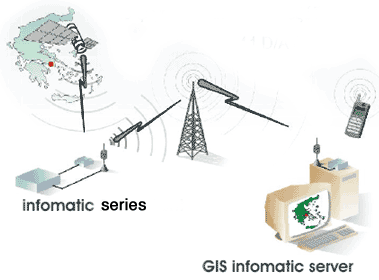
GIS Infomatic Server supports the real-time representation (REAL TIME SERIES) or the file log representation (DATALOGGER SERIES) of the Infomatic series devices location on digital maps.
Moreover, it is possible to monitor, manage and store all device actions (eg velocity, temperature and status of engine or oil) and improving their programming. It is also possible to manage the devices remotely.
The Main Features of the GIS Infomatic Server:
• Graphic data representation, in vectorial digital maps (municipality limits, areas, street names, house numbering, street width)
• Ability for zoom in / zoom out
• Optimum route estimation for vehicles base to shortest distance or time considering the daily gathered data from the Infomatic series devices
• Complete report & statistic system, with the additional function of exporting the results in Excel or Αccess format for further modification.
Server’s technical characteristics:
• Windows 2000 server
• User friendly Interface
• Digital map G.I.S usage
• Coordinates history from data base